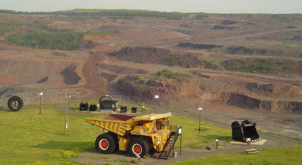
Named for Leonidas Merritt, one of seven brothers who discovered the Mesabi Iron Range, the Leonidas Mine began production in 1908. The overlook was created by mining overburden (surface materials that covered the ore body).
From here, visitors will see former mine sites, as well as the active mine, UTac, in Eveleth. This is the largest man-made point on the Iron Range. You will be able to view over 15 miles of breathtaking scenery from here. The water towers of several communities are also visible from here, as well as the Laurentian Divide, visible on the horizon as a low range of hills. (Water on the north side of the Laurentian Divide flows to the Hudson Bay, while that on the south finds its way to Lake Superior or the Gulf of Mexico.)
Directions: From Highway 53 Eveleth, take the downtown business district exit onto Park Avenue which turns into Grant Avenue. Follow 1.4 miles to stop sign. Take a right onto Fayal Road/Highway 101. Travel 1 mile and Leonidas Overlook is located on the left-hand side.
Longyear Drill Site
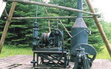
E.J. Longyear's historic first diamond drill site on the famed Mesabi Iron Range is located about 3 miles north of town on County Road 110. Visitors are directed along a 1/4-mile wilderness nature trail that leads to the actual 1890 drill site and the return trail crosses two foot bridges. Longyear began a new concept in iron exploration, forming the E.J. Longyear Company; for the next 21 years (1890-1911), he continued to explore and lease properties all along the 90-mile length of the Mesabi. He eventually directed the exploration of 7,133 test pits and diamond drill holes across the ranges and established today's worldwide Longyear Exploration Company. The Drill Site features displays of historic mining equipment, including the Sullivan Model 'H' Drill. Admission to the site is free; open April 1-November 30, during daylight hours.
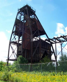
Bruce Mine Headframe
The Bruce Mine Headframe is the last standing headframe from the earliest period of underground mining on the Mesabi Range.
Located next to Highway 169 near the east entrance to Chisholm, the headframe was constructed in 1926 by International Harvester Company. This steel structure held the sheave wheels for cables that lowered and raised the cages & skips from the underground mining operation.
The Bruce Mine Headframe was once part of a complete mining complex including a dry house, engine house, sintering plant and 12 two-story frame houses with fireplaces for workers. All grounds were seeded and streets & alleys were graded, giving the area the complete appearance of a typical "mining town" of the 1930s.
The headframe itself is typical of the many seen on the Mesabi Range prior to 1940. One of only three remaining in the state, the Bruce Mine Headframe is listed in the National Register of Historic Sites and is located near the Minnesota Museum of Mines.
No admission. Open year-round.
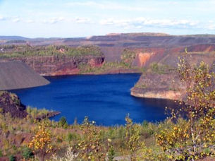
Finntown Overlook and Park
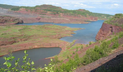
Visitors walk through a 50-foot caged safety bridge out into the midst of the historic Rouchleau group of mines. The mine pit extends nearly three miles long, a half-mile wide and 450 feet deep. Visitors experience towering rock-cropped walls with various red hues stretching across the entire open pit mine.
The Rouchleau Group of mines began as underground shafts, when other mines honey-combed the area a few hundred feet below the surface, eventually joining underground. This group of mines produced more than 300 million gross tons of iron ore within the Virginia District. Ten mining companies were involved in the Rouchleau in open pit mining at one time or another, with the last shipments being made in 1977.
The Finntown Overlook Park is a gateway to recreation with an entrance to a paved biking trail, The Mesabi TrailSM and direct access to more than 2,000 miles of scenic groomed snowmobile trails.
Located at the east end of 3rd Street North in Virginia past historic Kaleva Hall; three blocks north of Chestnut Street.
Free admission. The overlook is open year-round.
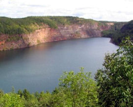
Hull Rust Mahoning Mine View
Visitors can view the largest operating open pit iron ore mine in the world, more than three miles long, two miles wide and 535 feet deep. This man-made "Grand Canyon of the North" was the first strip mine on the Mesabi Iron Range. The view continues to grow as the Hibbing Taconite Company Mine expands its mining operations. Rotary drills, 33-cubic-yard shovels and 240-ton production trucks can been seen in action at this National Historic Site.
Since 1895 more than 1.4 billion tons of earth have been removed on its 2,000 acres of land, and more than 800 million gross tons of iron ore have been shipped from the mine. At peak production in the 1940's, as much as one quarter of the ore mined in the United States came from the Hull Rust Mine.
A slide presentation in the observation building explains the colorful history of the mine and early miner's activities. An observation building, mine exhibits, mine shovel bucket, mining truck, interpretive graphics and a walking trail make the trip to the Hull Rust Mine View memorable.
Directions: Exit off Highway 169 in Hibbing onto Howard Street. Follow nine blocks (.7 miles) to 3rd Avenue East. Take a right and follow past the Greyhound Bus Museum (located on the left hand side.) Follow signs to Hull Rust.
Admission: Open mid-May through September, Monday through Saturday, 9 a.m. to 5 p.m., Sunday 1-5 p.m.
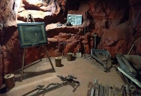
Croft Mine Historical Park
The Croft Mine started shipping iron ore in 1916 and ceased operations in 1934. By the time the Hanna Mining Co. closed the mine it had shipped 1,770,669 tons of ore. After closing, the mine sat quietly until 1978, when money was designated to restore the Croft Mine. The Croft Mine Historical Park opened in 1980. By 1999 the park had accumulated a large collection of documents, photographs, and artifacts,
Today there is a 17-acre park, built on the Croft Mine site. The original shaft was 630 ft. deep. There is a guided simulated underground mining tour and a museum with mining artifacts.
Located 8 blocks N of Hwy 210 on 2nd Ave NE. 2nd entrance (new) .5 mi N of Hwy 210 on Hwy 6 near Crosby, Crow Wing County, MN.
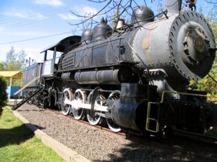
Mountain Iron Park & Wacootah Overlook
See a 1910 class S-4 Baldwin switcher steam locomotive weighing 82 tons, which was last used in the Mountain Iron Open Pit in 1955. Also on-site are a power shovel, bulldozer, large mining truck tire and a mining shovel bucket. From the park gazebo you'll view the Mountain Iron Mine that has been designated a Registered National Historic Landmark. Iron ore was first discovered on the Mesabi Iron Range in 1890 near present day Mountain Iron.
Take Highway 169 to CR 102 (Mountain Iron business district) exit. Take exit, and at the stop sign turn north onto CR 102 (Mineral Ave.) towards water tower. Continue one mile to the stop sign. Take left onto Main Street. Go two blocks (.1 mile) and take a right after Merritt Statue onto Mountain Avenue. The park is directly ahead (one block) on Locomotive Street.
To Wacootah Overlook follow Mountain Avenue to Main Street. Take a left on Main Street. Follow to Old Highway 169 which turns east (left) towards Virginia. Follow until you see the MinnTac gate, which will be on the left. Directly across from the gate on the north side is Wacootah Overlook. (Located approximately one mile from Mountain Iron Park and Mineview).
Free admission; open year-round.
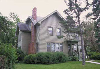
General Superintendent's House - Oliver Iron Mining Company
Mining companies did more than develop the mines, processing facilities and transportation networks needed to market the ore. They shaped the way communities throughout northeastern Minnesota were built. From platting townsites to erecting housing, the companies took the lead in establishing model communities to serve the mining industry and their employees. A look at facilities built by the Oliver Iron Mining Company across the Mesabi Iron Range reveals how the company provided for management and workers alike.
The General Superintendent’s residence at 100 Cole Ave., Coleraine, Itasca County represents just one of the building types, based on standard construction plans, that the company used throughout its land holdings in the region. Typical of company houses for management-level employees, this frame structure has multiple gables and roof dormers. Simple porticos shelter the principal entrances. This detail, often with a balustraded deck above, also was used on worker housing and company offices.
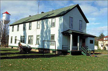
Boarding House - Oliver Iron Mining Company
The Oliver Iron Mining Company Boarding House on Jessie Street, Marble, Itasca County, is just one of the building types, based on standard construction plans, that the company used throughout its land holdings in the region. Similar boarding houses for single immigrant workers were erected in many smaller communities during the Mesabi Range’s boom period in the first two decades of the 20th century. One of four constructed in Marble, this boarding house is the only one that remains. Closed in the late 1920s, it was converted into a private residence.